Observation Assignment
The following is a report covering my experience interpreting and analyzing a fellow Capilano University student’s hand-drawn map of campus spaces. I gained the student’s verbal consent to participate prior to beginning this observation exercise. I also briefly gathered some “identifying characteristics” (Ashley) about them in order for me to “analyze their representational choices” (Ashley) based on these. This student is in their third year of the Communications degree program at Capilano, identifies as a male, and was first introduced to me in an upper level English course in which we are both enrolled this semester.
I provided the student with an 8/12” piece of white paper to draw on and a pencil to draw with. I gave them as much time as they desired to complete the drawing. After the student decided their drawing was complete, I asked them a few questions to help me with my interpretation and then took it home for further analysis. The initial questions I asked were primarily orientation focussed because many sites on the map are not labelled. My immediate impulse was to “organize [the piece] into a coherent pattern” (Lynch 3). My initial impression of their map was that it was one whose structures, “landmarks[,] or pathways are easily identifiable and…group into an over-all pattern” (Lynch 3) and yet I observed myself struggling with the scale of the drawing and felt slight “strain and anxiety” (Lynch 5) trying to remember names of structures without labels.
The student was visibly pleased when I was able to guess the first structure we identified and when I subsequently pointed out details they’d added and weren’t sure I’d notice, for example; the design structure atop the Library building. I found myself wanting to make notes on the map while we spoke immediately after they’d finished, but instead I chose to repeat my orientation questions more than once in order to memorize the answers. I decided that if I wanted to make notes, I would do it on a copy to preserve the map’s archival quality.
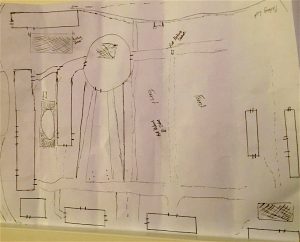
When I asked where the student began their drawing they explained that they began where their own route on campus begins (from the parking lots adjacent to Fir, Bosa, and Maple Buildings moving towards the other end of the page, in horizontal orientation, where they placed the Sports multiplex). They told me that they had focussed most on the area surrounding the Library Building as they saw this as an area of high traffic and superior architectural complexity to the other buildings. It was also perceived by the student as central spatially to the campus.
After leaving the student and taking the map away for further observation, I began to notice the aesthetics of the work. The student appears to have used a ruler, from their own pencil case, to draw only the major campus structures. They are all drawn in the same rectangular shape and have the placement of all the main entrances and exits marked without any other remarkable features. Small green spaces are shown as checkered etchings within rectangular boxes. Alternatively, large green spaces are simply marked “Forest”. Most pathways on the map are drawn fairly lightly while buildings have a heavier shade. Aside from one “Sitting Area” and a “Parking Lot” nothing besides two “First Nation Statue[s]” are labelled. These are statues which the student told me they pass on their way through the campus, as aforementioned, from the parking lot on the right of the page (if page horizontally oriented) towards the left. If the page remains in horizontal orientation, the two pathways leading downward from the Library Building (the circular structure in the centre of the page) have some dots in between them. I asked the student what these were and they told me that they were trees. The small structure with the circle to the right of the top of the Library building is meant to represent the bus stop. I found these two representations (the trees and bus stop) unique and intriguing as they were very different from those I imagine myself producing.
I found the Sports Multiplex (on the opposite side of the page from the Parking Lot label) the student drew particularly fascinating because it gave me the impression, based on the angle of the roads coming from both sides of it, that the student perceived the campus in a circular way and the Multiplex as having arms wrapping around the whole campus.
When I felt myself compelled to alter the map, I was forced to “think about [the m]any connections to the setting [of this map] that [I] have” (Van Hoonard 59) and how this was impacting my ability to view it with neutrality.
Accounts of observing others’ drawings are ideally “highly insightful and informative”. Some cases may produce overly “provincial, ethnocentric, or biased” (Van Hoonard 53) interpretive results dependant on the researcher. My attempt has been to avoid taking an overly value-laden approach, but these kinds of “accounts [do often] tell…us more about the writers and their social backgrounds than the cultures [or works] about which they [a]re writing” (Van Hoonard 53). The type of field research I conducted for this assignment was participant observation. When conducting this type of study, “a researcher attempts to understand everyday community life from the perspective of participants” (Van Hoonard 52). The intention of this approach is to be “useful to social science but not harmful to those observed” (Van Hoonard 52).
This exercise raised questions for me around the processes involved in the planning of the campus design as it is today and the current and ongoing factors impacting its future layout. The campus is like a city in that it is “not only…an object which is perceived (and perhaps enjoyed) by [large numbers] of people of wide diverse class and character, but it is the product of many builders who are constantly modifying the structure for reasons of their own. While it may be stable in general outlines for some time, it is ever changing in detail. Only partial control can be exercised over its growth and form. There is no final result, only a continuous succession of phases.” (Lynch 2)
Works Cited :
Ashley, Sean. “Module III – Making Observations, Observation Assignment : The Image of the Campus.” Liberal Studies Course Outline. Fall 2017, https://moodle.capilanou.ca/pluginfile.php?file=%2F1071572%2Fmod_resource%2Fcontent%2F1%2FM3%20-%20Observation%20Assignment.pdf
Accessed 25 October 2017
Lynch, Kevin. The Image of the City. MIT Press, 1960.
Marek, Radovan. Untitled Map of Capilano University Campus Spaces. 2017, pencil on paper, Vancouver, Canada.
Van Den Hoornard, Deborah K. “Observing social life through field research.” Qualitative Research in Action, Oxford University Press, 2012, pp. 52-73