Megan Amato
LBST 391-04
Cheryl Schreader
May 30th, 2019
Weather Synopsis of the North East of Scotland
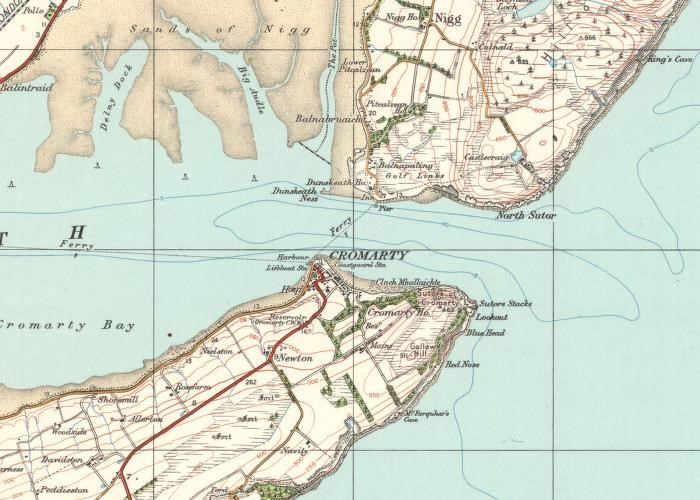
If I am to study a text of traditional myths in attempt pull out climate and weather patterns from the stories, I first need to understand the climate records of the region. Hugh Miller’s book titled “Scenes and Legends of the North of the Scotland” is a collection of folk tales and myths based in Cromarty. The small town is on the coast in the northeast of Scotland and sits between the Cromarty Firth and the Moray Firth (See fig. 4). Due to the towns small size—both in geography and in population—detailed climate reports are few and far between. Therefor, I will divide this synopsis into three parts: general climate history of Scotland; recent weather and climate patterns of Cromarty; and climate and weather history of the regions surrounding the Cromarty and Moray firths. The first part will give a general ideal of the weather patterns in Scotland and the second and third parts will provide a more detailed idea of the regional climate around Cromarty.
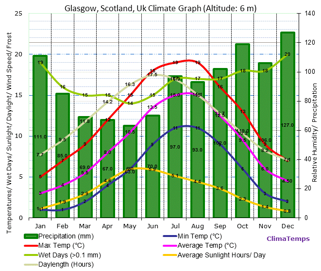
Fig
1. Glasgow Climate Graph from:
“Running in Glasgow.” By Great Runs,
http://greatruns.com/wp-content/uploads/2017/07/glasgow-climate-graph.gif
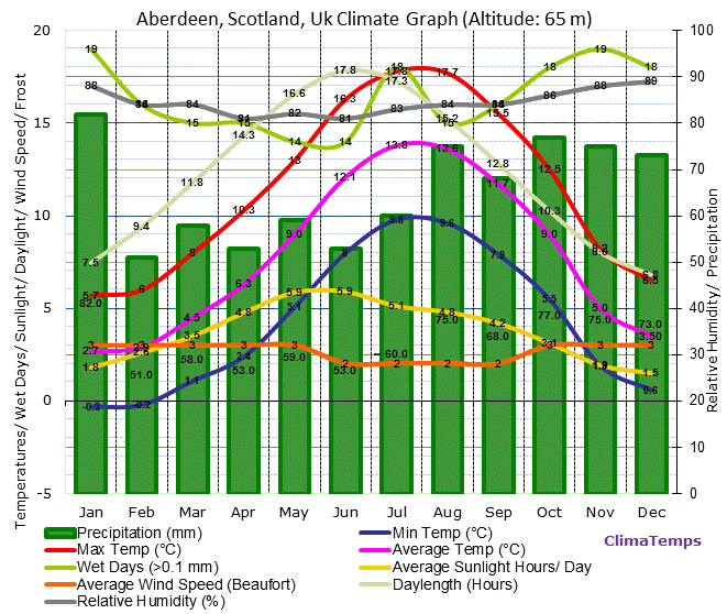
Figure 2. Aberdeen Climate Graph from: “Solar PV, Aberdeen and Me.” By Nordintown,
https://nordintown.com/blog/content/public/upload/aberdeen-climate-graph_0_o.gif
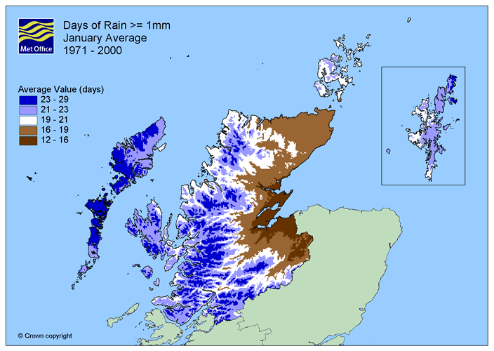
Fig 3. Average days of rain from: “Tain Range Climate” by MetOffice, metoffice.gov.uk/pub/data/weather/uk/climate/averages/maps/northscotland/7100_1km/RainDays1_Average_1971-2000_1.gif
Scotland
Scotland is the northernmost country on the island of Great Britain. It is generally located in a low-pressure system and has a temperate climate with wet, winters and mild summers partly in thanks to the North Atlantic Drift (environment.gov.scot/media/1185/climate-climate.pdf) which flows from Jamaica and keeps it warmer despite it being located at a higher latitude. However, due to the varied nature of its topography (lowlands, highlands, mountains, valleys, lochs, western/eastern coasts, islands etc.) the typical climate can also differ from region to region. The west coast of Scotland tends to experience more precipitation than the east (see Fig. 1 and Fig. 2) due to orographic rainfall as warm condensed air rises over the mountains in the Highlands and condenses (Dawson 29-30) much of the eastern Highlands lies in its rain shadow (see fig. 3). A climate report for Scotland reports that the western Highlands averages at 3000 mm of rain per year compared to 800 mm in the east. The highlands tend to be colder in the winter with higher altitudes but have longer hours of daylight. Temperature averages range from 5°C in the winter to 19°C in the summer. The wind tends to blow towards the southwest and average at 11kmh (esru.strath.ac.uk). Scotland provides 25% of wind power to the EU (rmets.onlinelibrary.wiley.com/doi/full/10.1002/wea.2290).
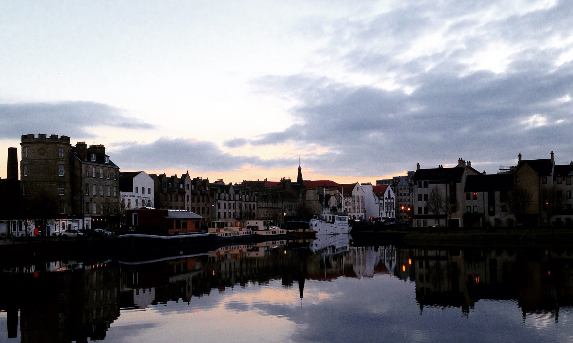
Cromarty
The town of Cromarty sits on headland that lies at the mouth of the Cromarty Firth which is a finger of the Moray Firth which leads to the North Sea. Average temperatures range from 2°C in January and February to 18°C in July and August. On average, it rains 18 days out of the month with slightly more rainy days in the winter and an average of 3.8 days of snow in the winter. The average amount of total precipitation is estimated at 700 mm per year (metoffice.gov.uk/climate/uk/regional-climates/ns). Due to its coastal location it is in danger of wave and wind erosion with Arctic winds averaging 14 kmh (myweather2.com). A recorded history of storms ranging from the 17th to 19th the century accounts to an altering of the landscape due to rising sea levels, high winds, and wave erosion (Dawson, 133). The sky is often overcast with an average of five hours of sunshine per day with as little as three days during the late fall and winter, and as high as seven days in the June and July. On average, Cromarty see’s two days of fog during the high summer and early fall, and one day of fog during the other months (myweather2.com/City-Town/United-Kingdom/Highland/Cromarty).
Cromarty Firth
The Cromarty Firth average temperatures range from 5°C in the winter to 12°C in the summer (jncc.defra.gov.uk/pdf/RIS/UK13009.pdf) and an estimate of 634 mm of annual rainfall (jncc.defra.gov.uk) with an average of 10 days of precipitation per month. With the protection of the headlands from the Moray and the North Sea, wind speed average 4kmh (windfinder.com).
Moray Firth
The average temperatures in the Moray Firth range from 3°C in the winter months to 15°C in the summer, and an average of 700 mm of rain with 10 days of precipitation per month. Average wind speed is 20 kmh. The coast sees more average sunshine than other Scottish regions (metoffice.gov.uk/climate/uk/regional-climates/ns).
Works Cited
“Climate Report.” Environment, www.environment.gov.scot/media/1185/climate-climate.pdf. Accessed May 24th, 2019.
“Cromarty Climate History.” MyWeather2, www.myweather2.com/City-Town/United-Kingdom/Highland/Cromarty/climate-profile.aspx?month=12. Accessed May 24th, 2019
“Information Sheet on Ramsar Wetlands.” JNCC. http://jncc.defra.gov.uk/pdf/RIS/UK13009.pdf. Accessed May 28th, 2019.
“Northern Scotland: Climate.” MetOffice, www.metoffice.gov.uk/climate/uk/regional-climates/ns. Accessed May 24th, 2019.
“Scottish Weather and Climate.” Scotland, scotland.com/travel/climate. Accessed May 26th, 2019.
“Weather Statistics for Moray Firth, Scotland.” YR.NO, www.yr.no/place/United_Kingdom/Scotland/Moray_Firth/statistics.html. Accessed May 24th, 2019
“Wind and Weather for Tain/Moray Firth.” WindFinder, www.windfinder.com/windstatistics/tain_moray_firth. Accessed May 26th, 2019.
Dawson, Alastair. So Foul and Fair a Day. Edinburgh, Birlinn Limited, 2009.